The Location and Resource page provides access to the solar resource library, which is a collection of weather files stored on your computer. When you first install SAM, it comes with a few default weather files in the library. As you use SAM for your own projects, you should add files to build your own library. Once files are in your library, you can use them for different projects and with different versions of SAM.
There are two ways to add files to your solar resource library:
1. Download files from the NREL National Solar Radiation Database (NSRDB)
Use the download weather file options and click Download and add to library to get the most up-to-date data from the NSRDB for long-term cash flow analysis, single-year analysis, and P50/P90 analysis.
2. Add weather file folders
If you have weather files from a source other than the NSRDB or that you've downloaded yourself directly from the NSRDB website, click Add/remove weather file folders to add the folder containing the files to the Solar Data File Folders list. SAM automatically adds any weather files it finds in these folders to the solar resource library so they will appear in the list.
When you install SAM, it creates the default download folder <user>/SAM Downloaded Weather Files folder where weather files you download from the NSRDB are stored. You can change that folder by clicking Add/remove weather file folders and changing the Folder for Downloaded Solar Data Files.
For a list of sources of data other than the NSRDB, see the Weather Data page on the SAM website.
See also
Notes.
You may want to model your system using weather data for several different locations around your project site, and if available, from different data sources to understand how sensitive your analysis results are to the weather assumptions, and how much variation there is in the data from the different weather files.
You can compare results for a system using more than one weather file in a single case by using SAM's parametric simulation option.
For more information about weather data, including where to find data for locations outside of the United States, see Weather Data on the SAM website.
For a helpful discussion of weather data and power system simulation, see Sengupta, M.; Habte, A.; Gueymard, C.; Wilbert, S.; Renne, D.; Stoffel, T. (2017). "Best Practices Handbook for the Collection and Use of Solar Resource Data for Solar Energy Applications: Second Edition." NREL Report No. TP-5D00-68886. (PDF 8.1 MB)

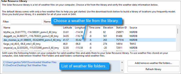
SAM's solar resource library displays information from weather files in your solar resource data folders. The default solar resource library that comes with SAM contains weather files for a few locations around the United States for the default configurations. As you use SAM, use Add/remove weather file folders to build a library of files for locations you frequently use as described in Folders and Libraries. To choose a file from the solar resource library: •Click the location name in the list. You can type a few letters of the file name in the Search box to filter the list. The full file name and information about the selected file appears under Weather Data Information. To see the data in the file, click View data.
Add/remove weather file folders Use the folder settings to tell SAM what folders on your computer it should scan for weather files to build the solar resource library. SAM adds any files it can identify as valid weather files in each folder you specify to the library. Before adding a file to the library, SAM checks the data in the file displays a message if it finds any problems with the data in the file. SAM will only add valid weather files to the library. If you add a folder that contains CSV files that are not in the SAM CSV format, it will not add those files to the library. The list of solar resource folders are the folders that SAM scans for weather files to build the solar resource library. Refresh library Refresh the library after adding files to the weather file folder. In most cases, SAM should automatically refresh the library as needed, but you may need to manually refresh it. |
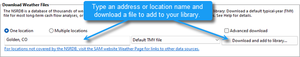
SAM can download weather files from the National Solar Radiation Database (NSRDB) Physical Solar Model (PSM) datasets: •Type an address and click Download and add to library to download TMY (typical meteorological year) data. •Check Advanced download and click Download and add to library to choose from all files available from the NSRDB for your location, including file with subhourly data, files for different years, and files from different datasets.
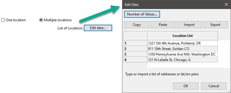
To download a TMY weather file for a single location: 1.Replace the text "Type a location name, street address or latitude and longitude" with a street address, city and state or country name, zip code, or latitude longitude pair. For example: •Golden, Colorado •golden, co •15013 Denver West Parkway, Golden CO 80401 •80401 •thimpu, bhutan 2.Click Download and add to library. For more instructions to download multiple files, see Weather File Download Instructions below. SAM converts the address you type to a latitude and longitude pair for the location, and submits that information to the NSRDB along with your email address. If the location is in the region covered by the NSRDB, it returns a weather file in the SAM CSV format, and adds it to your weather file download folder. Otherwise, it displays a message telling you the location is not covered by the NSRDB. When you first install SAM, it creates the SAM Downloaded Weather Files folder and assigns it as your weather file download folder. You can change the weather file download folder by clicking Add/Remove weather file folders. See Folders and Libraries for details. When the download finishes, SAM displays a prompt asking you if you want to open the weather file download log. This prompt is the indication that the download finished. During the download and before that prompt appears, SAM may become unresponsive. If it does, wait for the prompt to avoid interrupting the download. The weather file download log is a text file that SAM creates in your weather file download folder, and serves as a record of all of the files you download from the NSRDB. For each download, it lists the date and time of the request, the information you provided, the URL SAM generated, the name of the file returned by the NSRDB, or error messages it returns if the download fails. This information is useful for troubleshooting weather file download problems. Note. Downloading multiple weather files from the NSRDB can take a long time. If you download files for multiple locations or years, be prepared to wait for the files to download. The download log file reports the time it takes for each file to download. Download times depend on your internet connection and computer. For a new computer with a fast connection, downloading and processing a single file takes about 10 seconds. One location, Multiple locations Choose One location to download a weather file for a single location. Choose Multiple locations to submit a list of locations and download a file or files for each location. For Multiple locations, click Edit data to open the Edit Data window where you can enter the list of locations and click Number of Values to enter the number of locations in the list.
60-minute, 30-minute Choose 60-minute to download weather files with hourly time steps or 8,760 data records. Choose 30-minute to download files with 30-minute time steps or 17,520 data records. Thirty-minute data is not available for the NSRDB SUNY International dataset. Download options
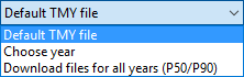
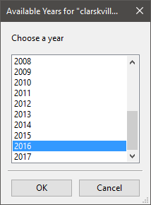
Default TMY file Download a typical meteorological year weather file for the location or locations you specified. Typical year data is appropriate when you are using simulation results for a single year to make cash flow calculations over a multi-year period. Choose a single year file to download. After you click the Download button, SAM prompts you with a list of available years for each location you requested to choose a year.
The single year option is appropriate when you want to see how the system would perform in a particular year. For example, for a residential or commercial system, if you have measured building load data for a given year, you could use weather data for the same year to see how the system's power output compares to the load. If you use both Choose year and Multiple locations, SAM prompts you for a year for each location. SAM queries the NSRDB to generate the list of available years. The list of available years varies between regions. Download files for all years (P50/P90) Download a set of single-year files covering the range of historical data (nineteen files for 1998 through 2017 as of October 2018 for PSM data). When you click download, SAM creates a folder in your weather file download folder to store the single year files based on the location address or latitude-longitude pair you typed. It also downloads the typical meteorological year (TMY) file for the location and stores it in your weather file download folder. SAM appends an underscore with the year to the file name so that the P50 P90 simulations work correctly. See P50/P90 Simulations for details. If you choose to download files for all years with Multiple locations, SAM downloads a set of files for each location, and puts the files for each location in a separate folder. Note that this may take a long time. Weather File Download InstructionsExamples of valid street address or latitude-longitude pairs: •golden colorado •golden, co •15013 Denver West Parkway, Golden CO 80401 •80401 •39.75, -105.15 •Super Market, F-6 Markaz, Islamabad, Pakistan •New Delhi, India Note. When the download finishes, SAM displays a prompt asking you if you want to open the weather file download log. This prompt is the indication that the download finished. During the download and before that prompt appears, SAM may become unresponsive. If it does, wait for the prompt to avoid interrupting the download. To download an hourly typical-year (TMY) weather file from the NSRDB (use this option for most situations): 1.Click One location. 2.Type either a street address or latitude-longitude pair. 3.Click 60-minute. 4.Choose Default TMY File. 5.Click Download and add to library. To download files for more than one location: 1.Click Multiple locations. 2.Click Edit data. 3.In the Edit Data window, click Number of Values and type the number of locations to create a table with a row for each location. 4.Type a street address or latitude-longitude pair in the table for each location. 5.Click OK. 6.Choose a time step, 60-minute for hourly, or 30-minute for 30-minute data. 7.Choose the type of file(s) you want to download as described below. 8.Click Download and add to library. |
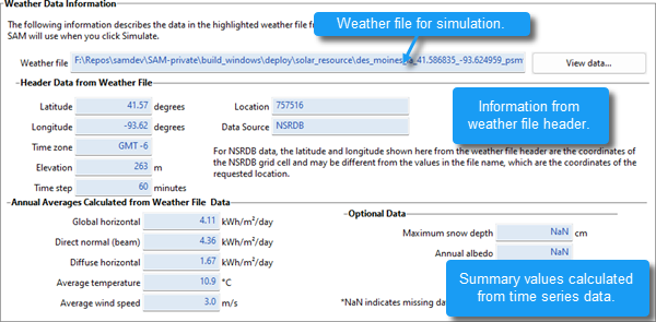
Weather File The path and name of the active weather file SAM will use for simulation. Download a different file from the NSRDB, or click a different file name in the library to change the file. View data Display weather file data in the time series data viewer. Note. You can also see the data after running a simulation on the Results page data tables and time series graphs. Header Data from Weather FileHeader data is information in the weather file that describes the location and type of data in the file. SAM uses the time zone, elevation, latitude and longitude to calculate the sun position during simulations. It does not use the city, state, country, and other descriptive information. Annual Values Calculated from Weather FileWhen you add a weather file to the solar resource library, SAM reads weather data from the file and calculates the annual values to display for your reference. It does not use annual values during simulations. Global horizontal, Direct normal (beam), Diffuse horizontal The sum of solar irradiance data (W/m2) in the weather file converted to kW and divided by 365 days/year. Average temperature The sum of temperature data (°C) in the weather file divided by the number of records in the file (8760 for hourly data). Average wind speed The sum of wind speed data (m/s) in the weather file divided by the number of records in the file (8760 for hourly data). Maximum snow depth If the weather file contains snow depth data, the maximum value of snow depth data (cm) in the weather file. NaN indicates the file does not contain snow depth data. Snow depth data is required for to model snow losses for the Detailed Photovoltaic and PVWatts models. Note. For information about where to find weather files with snow depth data, see the note on the Weather Data page of the SAM website. Annual albedo If the weather file contains albedo (ground reflectance) data, the average value of albedo values in the weather file. NaN indicates the file does not contain albedo data. |
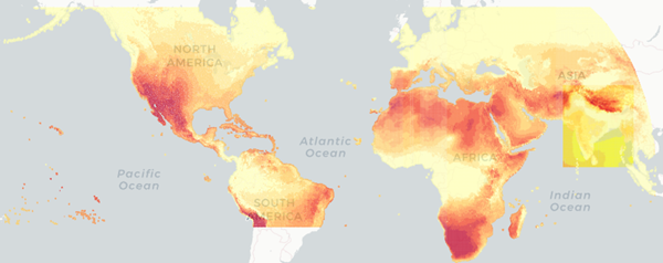
The NREL National Solar Radiation Database (NSRDB) is an online database of weather files containing solar resource data in the SAM CSV format. Files are available both as typical-year files and single-year files. The database covers the parts of the world shown in the map below. The current data is called PSM (Physical Solar Model).
Important Note for CSP Modelers! SAM's CSP models assume that each DNI value in the weather file represents the average irradiance over the time step, and calculate sun angles for the midpoint of the time step. For hourly weather files from the NSRDB, the irradiance data for each time step is measured instantaneously at the time indicated by the minute column. For hourly data, minute = 30, so the irradiance data is measured at midpoint of each hour. For subhourly data, the irradiance data is measured at the beginning of each time step. As a result, if you use an NSRDB weather file with a CSP model with subhourly data, the sun angle for each time step will be for a different time than the time for the instantaneous irradiance values. See Time Convention and Sun Position for additional details.
Notes. SAM downloads weather files with the following hourly data from the NSRDB: •Direct normal (beam) irradiance, DNI (W/m²) •Diffuse horizontal irradiance, DHI (W/m²) •Dry-bulb temperature (°C) •Dew-point temperature (°C) •Relative humidity (%), for single-year files only •Atmospheric pressure (mbar) •Wind speed at 2 meters above the ground (m/s) •Wind direction (°E of N) •Albedo Note. Weather files with snow depth data for the Detailed Photovoltaic model are not available from the NSRDB PSM dataset. They are available for 239 locations in the United States from the legacy MTS1 (TMY2) files in the original format, which cover the period 1961 - 1990. See Snow Losses for details. |
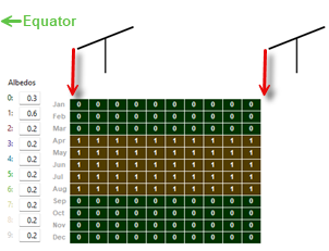
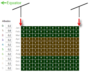
The albedo, sky diffuse model, and irradiance data inputs are advanced inputs for the detailed photovoltaic model that you can ignore unless you have a reason to change them. These inputs are not available for the PVWatts model, except for some albedo options, which are under Advanced Inputs on the System Design page. Note. Use the default DNI and DHI and Perez options unless you have a reason to change them. Definitions: AlbedoSAM uses the albedo (also called ground reflectance) to make a small adjustment to the amount of solar irradiance incident on the array to represent diffuse irradiance reflected onto the array from the ground. SAM also uses albedo to calculate irradiance incident on the rear side of bifacial modules. Albedo values must be greater than zero and less than one, where zero represents completely non-reflective ground and 1 represents completely reflective ground. For most analyses, you can use the default albedo value of 0.2, which is reasonable for grassy ground. A value of 0.6 would be reasonable for snow-covered ground. After running a simulation, you can see the time series albedo data that SAM uses for simulations on the Results page, and the spatial data on the Spatial tab of the results page. "Uniform" albedo data represents the albedo that is the same for the entire ground under the array. "Spatial" albedo data represents albedo that is different under and between rows in the array. Use monthly uniform albedo values Choose this option to specify albedo values by month. Click Edit Values to edit monthly albedo values for each month. Use monthly spatial albedo values Choose this option when you have spatial albedo data by month. The option is available for fixed, one-axis, and seasonal-axis tracking options on the System Design page. Each column in the spatial albedo matrix represents a rectangular strip of ground under one row of the array and the space between one row and its adjacent row. The leftmost column represents the row closest to the equator. Each row represents a month. The diagram changes with the tracking option on the System Design page and indicates how the matrix represents the ground:
You can specify up to 10 rectangular strips: Use your mouse to select cells in the matrix to represent the strip, and type a number between 0 and 9 for each strip. Then for each strip type an albedo value under Albedos. To see the resulting albedo, ground irradiance, and rear side irradiance, click the Spatial tab on the Results page after running a simulation. Use uniform albedo in weather file if it specified Check this option if you want SAM to use hourly or subhourly albedo data from the weather file instead of the monthly albedo values. You should also specify monthly albedo values because SAM uses those values for any time steps that have invalid albedo values: For each time step in the simulation, SAM checks the value in the albedo column of the weather file to see if it is between zero and one. If it is within that range, SAM uses that value for the albedo in that hour. If the value in the weather file is outside of that range for a given time step, then SAM uses the appropriate monthly albedo input value for that hour. If you want to add albedo data to a weather file, you can edit the file using a text editor or spreadsheet software. See the SAM CSV format description for details. Diffuse Sky ModelSAM's detailed photovoltaic model uses DNI and DHI data with sun and subarray angles to calculate the irradiance incident on each subarray. Calculating the incident direct component from the DNI is straightforward, but there are several methods for estimating the incident diffuse component from DHI. The incident diffuse component includes both ground-reflected diffuse irradiance, and sky diffuse irradiance from the sky dome outside of the sun's circle. SAM allows you to choose the method it uses to convert DHI data to incident sky diffuse irradiance. The isotropic model tends to under-predict the global radiation on a tilted surface, and is included as an option for analysis comparing SAM results with those from other models using this approach. The HDKR and Perez methods provide comparable estimates of the incident diffuse irradiance. For more details about these methods, see the photovoltaic reference manual, which is available for download from the SAM website. Isotropic The isotropic method assumes that diffuse radiation is uniformly distributed across the sky, called isotropic diffuse radiation. HDKR The Hay-Davies-Kluchr-Reindl combination method accounts for the increased intensity of diffuse radiation in the area around the sun, called circumsolar diffuse radiation, in addition to isotropic diffuse radiation. Perez The Perez method is the default value and is best for most analysis. It accounts for horizon brightening, circumsolar and isotropic diffuse radiation using a more complex computational method than the Reindl and Hay and Davies methods. Weather File Irradiance DataA weather file in SAM CSV format for the photovoltaic performance models must contain at least two columns for the solar irradiance components or a single column for plane-of-array (POA) irradiance. The weather file may contain columns for all three irradiance components in addition to POA data. SAM determines which columns to use for the simulation based on the Weather File Irradiance Data options you choose. Unless you choose one of the POA options, SAM's detailed photovoltaic model always requires the DNI and DHI components to calculate the irradiance incident on each subarray. When you choose the DNI and GHI or GHI and DHI options, SAM calculates values for the missing irradiance component from the two components that you specify, even if the weather file contains data for the missing component. When you choose a POA option, SAM bypasses the incident irradiance calculations. DNI and DHI SAM reads the direct normal irradiance (beam) and diffuse horizontal irradiance data from the weather file. For this option, SAM calculates incident irradiance using the DNI and DHI data from the weather file without any additional calculations. This is the default option, and is best for most analyses because it minimizes the number of irradiance calculations. DNI and GHI SAM reads the direct normal irradiance (beam) and global horizontal irradiance (total) data from the weather file, and calculates the diffuse horizontal irradiance values for simulations. SAM calculates the incident irradiance using the DNI data from the weather file and the calculated DHI data. GHI and DHI SAM reads the global horizontal irradiance (total) and diffuse horizontal irradiance data from the weather file, and calculates direct normal irradiance values for simulations. SAM calculates the incident irradiance using DHI data from the weather file and the calculated DNI data. POA from reference cell Use this option if your weather file contains irradiance data measured in the plane of the array by a reference photovoltaic cell that has the same optical characteristics as the cells in the array. SAM assumes that the POA data accounts for angle-of-incidence (AOI) effects and removes the calculation of AOI-related reduction in incident DNI from the performance model. POA from pyranometer Use this option if your weather file contains irradiance data measured in the plane of the array by a pyranometer. SAM uses a POA decomposition model to calculate the DNI and DHI components of the POA irradiance for angle-of-incidence effect calculations. Notes about the POA input options. Irradiance Data in ResultsNote. If your weather file contains data for all three irradiance components, the value of the calculated third component that SAM uses for the simulation may differ from the value in the weather file. You can see the calculated data on the Results page after running a simulation, for example, on the Data tables tab and Time series tab: Irradiance GHI/DNI/DHI/POA from weather file (W/m2) The data in the weather file. If the column does not exist in the weather file, SAM reports the values in the results as NaN (not a number). Irradiance GHI/DNI/DHI calculated (W/m2) The values of the third irradiance component that SAM calculates from the other two in the weather file. For example, if you choose the DNI and GHI option, you should see Irradiance DHI calculated in the results. SAM uses the following equations for the calculated values, where z is the sun zenith angle: GHI = DHI + DNI × cos(z) DHI = GHI - DNI × cos(z) DNI = ( GHI - DHI ) ÷ cos(z) For the POA options, SAM calculates the DHI and DNI values from the POA data in the weather file using the method described in Marion, B. (2015) “A model for deriving the direct normal and diffuse horizontal irradiance from the global tilted irradiance.” Solar Energy, vol. 122, pp. 1037-1046. Subarray [n] POA total irradiance after shading and soiling (W/m2) The total irradiance incident on each subarray n. |
||
|